Home Why
AWOS?
Service
to Pilots
Meets
All  Requirements
Affordable
By Any Airport
Easy to Buy 'How To' Information & Videos

Map of SA Sites

Maintenance
& Support
FAA
Certifications
References
FAA AIP  Direct
Easy to Install Easy to Maintain

See Remote Data

AWOS Doesn't Have to be So Hard!
FCC & FAA Authorized SuperAWOS Right on Unicom
Where Pilots Need it Most

(Eliminates 18-24+ month delay for a discrete AWOS frequency)

Installs easily in just a few hours
Serving pilots the same day
Background Info on Solar Power

Check your Airport's Information with FAA Online
SuperAWOS
Startup Video
Set Altimeter Video
Set Visibility Video
Netlink Manual

TOPIC
BOOKMARKS
History of AWOS Notice of Proposed Construction AWOS Advisory Circular NAVAIDS
Objectives of AWOS AWOS Siting Criteria Airport Standards FCC
FCC 87.237
Multicom Station License
Now Available
Installation & Setup Manual Netlink Manual  

The History of Traditional AWOS Systems

The original 1970's AWOS siting requirements were developed by the National Weather Service to provide homogeneous settings for their scientific measurement equipment; to gather comparable sensor data at locations across the USA for national meteorological modeling.  The idea was for six knots of wind at location 'A' to be weighted equivalent to six knots of wind at location 'B.'  To implement this nationwide program NWS needed as many similar sensor location as possible across the USA.

FAA had set flight requirements for 'approved weather' for commercial flight operations, but was no longer able to support the army of human weather observers necessary to meet these requirements, even at the relatively small number of commercial airports.

To solve their mutual dilemmas, NWS and FAA decided to put NWS systems at airports, in one stroke giving NWS lots of similar locations, and providing approved weather for commercial flight operations where human observers were no longer supportable.  In comparison to each human weather observer costing over $150,000, those $250,000 NWS ASOS systems were a bargain!

And so AWOS/ASOS came to a few large airports, at considerable financial cost...

In 1977 this was a bargain!

History of AWOS Siting Requirements

For NWS, the optimal scientific platform has its wind sensor atop a 30 foot rigid mast, and requires a bunch of rigid structures mounted to elaborate rigid footings on the surface, to make the darn thing work  (See photo left).

One of FAA's primary missions is to protect airspace from encroachment by obstructions hazardous to flight operations; so sticking a 30 foot rigid mast into an airport's protected airspace was not acceptable.  FAA therefore established siting criteria to keep these rigid structures outside of an airport's Part 77 airspace (See drawing below).

For the relatively small number of large airports that were the 'first-pass' for needing automated weather, this standard was easy and made a lot of sense.

Traditional ASOS System
$250,000 +

Legacy AWOS on an oil platform in the Gulf - Part of FAA NextGen

Notice the wind sensor is NOT on a 30 foot mast

NOR is it clear 500 feet around the sensor!

Traditional Siting Criteria - Protecting Airspace from a 30+ Foot Rigid Mast

Text Box:  

Text Box: 30 ft +

HOWEVER, for the greater number of smaller airports that also need automated weather for flight-safety, but have neither spare land nor open space available.  Traditional siting constraints designed for large airports would inadvertently preclude these airports from having any form of Automated Weather (See below).

If 'rigidly' applied without judgment,
Standards can preclude safety

Whoops!


AWOS Objectives => FLIGHT SAFETY

The weather information pilots need for flight safety is defined by the regulatory 'flight requirements' applicable to the kind of weather in which they are flying:

  • Visual Flight Rules 'VFR'
    During clear weather Visual Flight Rules (VFR) pilots can see out their windscreen where they are, and what is around them, so they use windsocks, blowing tree-tops, eyeballs, and their common-sense.

What a lovely day!

  • Instrument Flight Rules 'IFR
    During low-weather Instrument Flight Rules (IFR) in-the-clouds conditions pilots cannot see anything at all, so they must navigate entirely by their aircraft's onboard instruments.
     

  • Altimeter  For a Pilot to maintain their height above obstructions which they cannot see they need a local ALTIMETER value, which they use to calibrate their aircraft altimeter to determine their height above unseen obstacles.
     

  • Visibility  For the Pilot descending through the clouds considering landing, they need surface VISIBILITY.   The pilot descends along a pre-determined 'Instrument Approach Procedure' (IAP) to its lowest 'Decision Height' (DH) above the runway.  If at DH the pilot can see the runway they land; if they cannot, they either go 'missed' and try the entire descent procedure again, or they go to another airport where the weather (visibility) is not so bad. 

Non-commercial pilots (Part 91) are free to descend to minimums and then see if they can see the runway, commercial pilots (Part 135+) are supposed to know they have adequate visibility to see the runway before they go down and take a look around.

I can't see a bloody thing out there!

  • Applicable Standards

The technical requirements to provide certified ALTIMETER to pilots are essentially dual, calibrated pressure sensors, adjusted for field elevation, configured to eliminate common-mode errors that could affect both sensors at the same time.  The sensors are initially calibrated to a high standard and thereafter against each other by correlation.  The technical requirements for VISIBILITY are a known, tested, trusted, reliable, and somewhat exotic visibility sensor.  Similarly, this sensor is initially calibrated to a high standard and then monitored for deviation from that standard, periodically recalibrated as necessary.


ONLY
CERTIFIED ALTIMETER & VISIBILITY
ARE REQUIRED TO MEET
ALL FLIGHT REQUIREMENTS
FOR PRIVATE AND COMMERCIAL
FLIGHT OPERATIONS
 

FAA ORDERS FAA Orders are FAA's instructions to its own people about how to do things for its own federally-owned systems.  
FAA orders do not extend FAA's statutory authority over non-federal systems!

That said, like FAA Advisory Circulars, FAA Orders represent a written record of the knowledge that was available when they were written. 
Many FAA orders are teribly ancient, and terribly out of date, but can provide useful guidance for current systems and methods

AWOS SITING CRITERIA  FAA Order 6560.20B

This FAA Order applies to federally-owned AWOS, but also contains good guidance for non-federally owned AWOS as well. 

For an AWOS "A+V" the Siting requirements only apply to the certified ALTIMETER and VISIBILITY, everything else remains advisory and is beyond the scope of this order. 

In sum, for AWOS A+V these requirements are limited to:

CERTIFIED ALTIMETERS

There must be two altimeters providing continuous correlation with each other; isolated from potential common-mode errors, and from effects of HVAC in a building, or wind whipping around a tower.

CERTIFIED VISIBILITY

The visibility sensor must be ten feet above the surface.

OTHER FEATURES ARE ADVISORY

Simplified & Appropriate siting for any (Talking) Windsock:  Any windsock provides perfectly acceptable wind information, windsocks are neither 'calibrated' nor 'inspected.'  An airport windsock is smaller than a traditional AWOS, less than 20 feet tall, and frangible. 

NOTICE OF PROPOSED CONSTRUCTION FAA Order 7460

The paper forms for submitting a 7460 notice are seriously out of date; they instruct you to mail them to places that don't exist and wait for an answer that may never arrive.  Instead, you now use FAA's new online website to get this done quickly and easily.

Have your Airport Consultant or Engineer (or feel free yourself!) to use FAA's online tools to get quick and definitive results.  Or, as always, feel free to contact us directly if you need further assistance (800 207 8999)

1. ESTIMATE LAT,LON, and ELEVATION FOR YOUR SUPERAWOS
Use easy online tools like earth.google.com, or equivalent.  example 
Allow a reasonable margin of error for whatever you choose to use!
2. TRY YOUR PROPOSED COORDINATES USING FAA'S NOTICE TOOL
Enter your values into FAA's Online Notice Tool (Add the SuperAWOS 16ft height when asked).  FAA's tool will tell you immediately whether or not your proposed location "exceeds notice requirements,"  and even tells you how much to correct for your next try: "You exceed Notice Criteria by 10.0 feet. The nearest airport is 50F, and the nearest runway is 35."  
That's FAA speak for "Try Again using New Coordinates!"
3. E-FILE YOUR 7460 Once you've got a good SuperAWOS location using the online tool, create a new user record on FAA's website to track your electronic 7460 submission. 
4. NOTIFY FAA  Enter the details you determined using FAA's tool.  Then SUBMIT.  The FAA application will give you a little online map where you re-verify its location.  example  You have now completed the 7460 submission, having pre-determined that your proposed installation is not an obstruction.

You have now provided FAA the required notice!


Example
FAA
Final Determination
7460 Submission


It's NOW ALL ONLINE

https://oeaaa.faa.gov
WAY TO GO, FAA!


!!! ATTENTION 7460 Submitters !!!
Remember to include these 'remarks'
when submitting your 7460

  !!! INCLUDE THESE REMARKS IN YOUR 7460 !!!
1 Installed clear of
Obstruction Free Zone (OFZ)
as per
FAA AC 150/5300 Section 306


(Equip Height only 16ft AGL)

Min distance from
Runway centerline

> 125 ft
Small aircraft and
Lowest IFR Approach
VISIBILITY 1 mile or greater

> 250ft
Large aircraft or
Lowest IFR Approach
VISIBILITY less than 1 mile

2 Equipment is frangible

Knocks over
If hit by an aircraft

3 Installation is co-located
with existing lighted windcone
If not, obstruction light installed

Obstruction
Marked & Lighted

4 Frequency - Unicom/CTAF
Operates under FCC 87.219
Frequency coordination
NOT required

Greatly simplifies
this process!

5 Frequency XXX.YYY Mhz
(Your current unicom)
Emmission Type 6K00A3E

On Unicom
Under 10 watts

 
FAA ADVISORY CIRCULARS

Advisory circulars are advisory, they have not gone through any rulemaking process, thus they do not have the oversight or accountability imposed as part of any rulemaking process.  As such, advisory circulars are non-enforceable.  Otherwise the local police could write rules about how to fold your socks, and you would immediately be subject to arrest if you didn't fold your socks according to their procedures.

That said, Advisory Circulars represent the accumulated knowledge of the time they were written, they are not exclusionary.  If you read the pre-amble to most ACs they specify they are not regulatory, and are only guidance documents.


AWOS
AUTOMATED WEATHER
OBSERVING SYSTEMS

AC 150/5220.16


FAA certified SuperAWOS
Under AC 150/5220.16

FAA Certification of SuperAWOS
Included
EQUIPMENT and MANUALS

Which specify how to do things
with FAA APPROVAL
!


AIRPORT STANDARDS
AC 5300.13

It is common-practice to install frangible (breakable) structures that are placed 'for function' where common-sense suggests:   AC 5300-13

305. RUNWAY SAFETY AREA (RSA). The runway safety area is centered on the runway centerline. Tables 3-1,3-2, and 3-3 present runway safety area dimensional standards. Figure 3-1 depicts the runway safety area.
a. Design Standards. The runway safety area shall be:
(1) cleared and graded and have no potentially hazardous ruts, humps, depressions, or other surface variations;
(2) drained by grading or storm sewers to prevent water accumulation;
(3) capable, under dry conditions, of supporting snow removal equipment, aircraft rescue and firefighting equipment, and the occasional passage of aircraft without causing structural damage to the aircraft; and
(4) free of objects, except for objects that need to be located in the runway safety area because of their function. Objects higher than 3 inches (7.6 cm) above grade should be constructed,

There are also areas near the runways to be kept clear of obstructions,
Proportional to the size of aircraft and the lowest visibility on an IFR approach

306. OBSTACLE FREE ZONE (OFZ). The OFZ clearing standard precludes taxiing and parked airplanes and object penetrations, except for frangible visual NAVAIDs that need to be located in the OFZ because of their function.

AC 5300.13  Table 16-4. (Obstruction Free Zone)  OFZ
OFZ and threshold siting surface for minimums of > or = 1 statute mile and > or = 400 feet
1. OFZ1 - The OFZ is the airspace above a surface centered on runway centerline whose elevation at any point is the same as the elevation of the nearest point on the runway centerline. The runway OFZ extends 200 feet (60 m) beyond each end of the runway.

Its width is:
a. 400 feet (120 m)  [+/- 200 from centerline] for runways serving airplanes of more than 12,500 pounds (5 700 kg) maximum certificated takeoff weight, and
b. 250 feet (75 m) [+/- 125 from centerline] for runways serving airplanes of 12,500 pounds (5 700 kg) or less maximum certificated takeoff weight exclusively.

307. OBJECT FREE AREA. The runway object free area (OFA) is centered on the runway centerline. The runway OFA clearing standard requires clearing the OFA of above ground objects protruding above the runway safety area edge elevation. Except where precluded by other clearing standards, it is acceptable to place objects that need to be located in the OFA for air navigation or aircraft ground maneuvering purposes and to taxi and hold aircraft in the OFA. Objects non-essential for air navigation or aircraft ground maneuvering purposes are not to be placed in the OFA.

The logical conclusion is to apply AC 5300.13 criteria to the setback distance from the runway centerline (Obstruction Free Zone) for your SuperAWOS.  In brief, the minimum setbacks start at

For airports serving small aircraft <12,500 lbs
IFR approach visibility of one mile or more
125 feet
Minimum setback from centerline


See
AC 5300-13
See section 306
Go to page 22

(2.4 Mbyte file!)

For airports serving larger aircraft > 12,500 lbs
IFR approach visibility less than one mile
250 feet
Minimum setback from centerline


FEDERAL REGULATIONS

NON FEDERAL NAVAIDS
      
    FAA Part 171 CFR TITLE 14--Aeronautics and Space

A 'navaid' is a radio transmitter that provides electronic navigation, a two or three dimensional course that aircraft follow. 

There is no mention of AWOS anywhere in this regulation
AWOS systems do not provide navigation (course guidance)!

Part 171 reads as a listing of abandoned, and soon to be abandoned FAA navigational systems:  VOR, NDB, ILS, Simplified Directional Facility (SDF), DME, Marker Beacons, Interim Standard Microwave Landing System, and the venerable Microwave Landing System (MLS).

Within each section, applicable to its particular navigation transmitter, are some useful guidelines for good practices: Owner is responsible to provide qualified maintenance personnel, physical security to prevent tampering, maintenance and operations by authorized persons only, etc.

FCC REPAIR LICENSE

Getting a discrete VHF frequency for a legacy AWOS remains extremely cumbersome.    Years ago, AWOS systems were routinely connected to a nearby navigational aids, such as these, to output the AWOS weather message.  To adjust a navigational transmitter requires someone who knows what they were doing; an FCC Repair License is required to make adjustments to a transmitter.  A licensed FCC technician should know how to read their test equipment, which they will need to assure a transmitter is behaving within specification.

The SuperAWOS transceiver has no field adjustments, it is a sealed unit; only the manufacturer (us) can make any adjustments.  The only action possible on the transmitter in the field is to remove and replace; after which the system performs all the diagnostics a technician could perform, which are reported to us remotely. 

There is no regulation requiring an FCC repair license to remove and replace a sealed, non-adjustable transceiver module!

PERIODIC VERIFICATION OF TRANSMITTER

Legacy AWOS systems transmit in the blind on a discrete frequency.  Should their transmitter fail for any reason, no one will know (unless a pilot happens to notice and is inclined to tell the FAA). 

There are four measures necessary to verify a radio transmitter is functioning

Frequency Is the transmitter transmitting on the right frequency?
Power Is the transmitter putting out the minimum power?
Modulation Is there any voice modulation over the RF carrier?
VSWR Is the antenna actually radiating any energy?

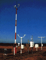
Legacy AWOS systems lack means to monitor these performance parameters, so they require someone knowledgeable, with test equipment, to periodically go to the site and check the transmitter.  These tests require sophisticated radio test equipment, and an FCC licensed technician to know what they are doing.

Realizing the validity of this need, we built into the SuperAWOS internal diagnostics that measure ALL of these parameters every day, which are also reported to us daily.  If there is any out of tolerance condition we know it within 24 hours, and an exchange plug & play module is on the way; no license required.  When the module is swapped in the field, which requires no tools, the system runs a complete transceiver test that confirms for us, and for FAA, that all parameters are within tolerance.


FCC Automated Unicom - 87.219  Sub Part G

In 1996 the FCC created FCC 87.219 specifically to allow this system, (which FCC called Automated Unicom, because that is the radio spectrum it shares) to share existing Airport VHF Common-Traffic Advisory Frequencies (CTAF); unicom and multicomm.

  • As an FCC approved transmitter, each SuperAWOS has an FCC DEVICE LICENSE (A little label physically attached to each internal transmitter)
  • The Airport is granted AUTHORITY over its  assigned unicom frequency by virtue of the Airport's FCC UNICOM STATION LICENSE
  • SuperAWOS is an FCC APPROVED DEVICE (transmitter) operating under the AIRPORT'S AUTHORITY

If you have questions about your Airport unicom station license, here are links to help you navigate FCC.GOV

HOW TO FIND
YOUR AIRPORT'S FCC
UNICOM STATION LICENSE
Online printable form for mailing into FCC with weird stuff pre-filled
HOW TO APPLY FOR FCC REGISTRATION NUMBER (FRN)
SAMPLE OF COMPLETED FCC APPLICATION FORM
BLANK FCC APPLICATION FORM TO BE COMPLETED
FCC does have an online application system, but it is very difficult to use

FCC Unicom Station Renewal Paper Form*Each transmitter has a DEVICE license, which is a certification that the transmitter operates in accordance to FCC requirements.  Each SuperAWOS, with its embedded transceiver, operates under the AUTHORITY of the Airport to use its own assigned CTAF.  Anyone using the CTAF does so with the permission of the Airport (or not).  if someone interferes with the Airport's use of its licensed frequency, then the Airport can file an 'interference' complaint, which allows the FCC to protect the Airport's use of its frequency (for example from crazy neighbors with a hand-held radio).

Interestingly, by prior coordination, Ken Kraus, then head of the FAA AWOS program, inserted into the FCC's Automated Unicom ruling '96-1' in 1996 the standard for automated unicom sensor locations:

(5)  If weather information is provided by an automated unicom:

     (i) weather sensors must be placed in order to adequately represent the weather conditions at the airport(s) to be served;

That's pretty obvious!